Note: "Mumble Foo Bar" is a made-up place that is meant to represent whatever place you are looking for. Whatever is said in this FAQ about Mumble Foo Bar applies to your location as well.
Q: Your tide predictor web site blah blah blah...
A: I am not the maintainer of the web site you have found. I am the maintainer of XTide. Although many tide-predicting web sites use some version of XTide behind the scenes, I have no control over the behavior of those web sites or their maintenance, nor do I receive any commissions from any advertising that may appear on them. The XTide software and required data are available free of charge from flaterco.com/xtide/files.html, with documentation at flaterco.com/xtide.
Q: Can you send me predictions for Mumble Foo Bar?
A: I cannot possibly provide this level of service to everyone who wants it. Please use a commercial service and/or a web site.
Q: URGENT - DROP EVERYTHING AND READ THIS! The race starts in 5 hours so I need a tide chart for Mumble Foo Bar NOW!
A: You might not believe it, but sometimes I go two weeks without reading my e-mail. Really! And when I do get back to it, there are always lots of messages just like this one, so far past their use-by dates that green fuzz has started to grow on them. The answer is the same: I cannot possibly provide this level of service to everyone who wants it. Please use a commercial service and/or a web site.
Q: The ads on your web site are driving me nuts! Is there any way to turn them off?
A: I am not the maintainer of the web site with which you are having a problem. I am the maintainer of the XTide software that you can get free with no ads from flaterco.com/xtide. Others have profited by selling advertisements on other web sites built using my software, but I give away the software freely to anyone who will make the effort to install it, so nobody really needs to be using those web sites.
Q: Can you tell me where I can find a web page with predictions for Mumble Foo Bar?
A:
Q: Can you please add predictions for Mumble Foo Bar?
A: Probably not. Please read the section entitled What to do if your location isn't listed.
Q: How do I make the calendar print all on one page?
A: If you are looking at a calendar in a web browser, try different scaling, fit, portrait, and landscape options in print preview until the calendar fits nicely on a page. For a more complete answer and/or instructions tailored for Linux, see Appendix C.
Q: Can you tell me the offsets for Mumble Foo Bar?
A: You can get them easier than I can by checking the sources described in the section entitled What to do if your location isn't listed.
Q: There are multiple listings for the same place, and they give different results. What's going on?
A: There are two different approaches to predicting the tides at a given place. One approach is to calculate them directly from a data set; when this is done it is called a "reference station." The other approach is to estimate them using adjustments to the tides at a nearby reference station; when this is done it is called a "subordinate station."
Data gathered from the NOAA web site sometimes include both a reference station and a subordinate station for the same place. For example, the subordinate station may be used for published tide tables while the reference station is still relatively new and untested. The results will differ, but they should be close (assuming that there are no problems with the data). If you are concerned about matching predictions up with those from some particular source, you should try each data set and see which one matches the best.
In rare cases, data gathered from the NOAA web site include two reference stations or two subordinate stations with exactly the same name and nearly the same location. When this happens, one of them has (2) suffixed to its name. Again, if you are trying to match official predictions, you should try both to determine which is better.
If you are using old legacy data or a web site that does, you may see additional listings for the same place. These may be expired and/or have dubious traceability to authoritative sources. They cannot be expected to agree with up-to-date predictions.
Q: Can you predict the tide and/or current if I give you the latitude and longitude?
A: The short answer is no. XTide cannot predict tides unless you provide harmonic constants (see What to do if your location isn't listed).
From what I'm told, the tide models that were built from TOPEX/Poseidon data work on a global scale, but they are inaccurate on continental shelves. Some organizations have constructed models that function in coastal waters in localized regions. For example, NIWA has a model for New Zealand's coastal waters, and NOAA has a model of currents in San Francisco Bay. Although XTide could make use of harmonic constants generated from these models, XTide does not implement any such models.
A: XTide reports coordinates in degrees only. Some sources report coordinates in degrees and minutes and run these together in a confusing way. For example, a coordinate shown as 2846.330 may actually mean 28 degrees, 46.330 minutes, which XTide would report as 28.7722 degrees.
If that is not sufficient to explain the discrepancy, or if there is some other cosmetic problem like the location name being spelled wrong, check NOAA's web site to see if the problem exists there. If it does, please report the problem to NOAA as well as me, and I will attempt to ensure that the correction is included in the next annual update.
Q: I want to change the graph in lots of ways, e.g., omit the station name, draw different depth lines, add more event types; how can I do this or will you add settings for it?
A: XTide supports a fair number of options to customize the graph. However, graphing is not the core function of XTide. If complete control over graphing is important to you, you should use XTide's raw and plain modes to export the raw level data and min/max predictions respectively to text files, import these into R, Gnuplot, or whatever is the "flavor of the month" for graphing and plotting, and then draw what you like using these more powerful tools.
Q: Can I still install XTide if I do not have root?
A: Yes. Follow the installation instructions, and just use paths in your home directory instead of system-wide directories. Following is one example of how it would work if you have installed dependencies (libraries) under /home/myacct/local and wish to install xtide in the same directory tree.
bash$ # install harmonics file
bash$ tar xvf harmonics-dwf-YYYYMMDD-free.tar.xz
bash$ mkdir /home/myacct/local/share/xtide
bash$ mv harmonics-dwf-YYYYMMDD/*.tcd /home/myacct/local/share/xtide
bash$ # The following should go in ~/.bash_profile to make it permanent
bash$ export HFILE_PATH=/home/myacct/local/share/xtide
bash$ # compile and install XTide
bash$ ./configure --prefix=/home/myacct/local CPPFLAGS="-I/home/myacct/local/include" LDFLAGS="-L/home/myacct/local/lib -Wl,-rpath,/home/myacct/local/lib,--disable-new-dtags"
bash$ make
bash$ make install
In the unlikely event that you wish to run the web interface xttpd, you will need to run it on an unprivileged port as described in Running the web server.
Q: I am trying to compile XTide with an unknown version of GCC, and I had the following problems....
A: XTide requires GCC version 4.4 or newer. Type gcc -v to find out what version you
have.
Q: I am trying to install XTide on a server that my web hosting company, contractor, or employee has configured in a nonstandard way and/or not updated in years. Their support is unhelpful. Please help me to get XTide to work on this server.
A: Sorry, but no. This is a problem with the service that your web hosting company, contractor, or employee is providing; it is not an XTide problem. In my experience, working around problems on a mismanaged or merely unmaintained server is an unending game of Whac-A-Mole. Your time would be better spent searching for a more competent web hosting company, contractor, or employee.
Q: When compiling XTide with a modern version of GCC on a well-maintained computer, I get errors like....
A: Please refer to the troubleshooting section of the installation instructions. If your error is not discussed there, please email dave@flaterco.com for assistance.
Q: What is the significance of the estimated bounds printed by stats mode?
A: The stats mode of XTide prints estimated upper and lower bounds that are calculated based on the 6 most significant tidal constituents simultaneously taking on their maximum and minimum possible values in the prediction model. These are not true bounds in the mathematical sense, since any station having more than 6 constituents could potentially generate predictions that exceed them. However, in practice, these estimated bounds are seldom exceeded by generated predictions.
Stats mode also determines and outputs the maximum and minimum predicted by the model within the span of time specified by the user. This generally provides a narrower interval, and one that is equally valid for the span of time specified. However, these bounds will vary depending on the span of time searched, while the estimated bounds are nearly constant.
Actual observed heights may exceed any and all bounds of the prediction model (e.g., in case of tidal surge from a hurricane). The highest and lowest water levels actually observed and recorded at a reference station during the official tidal epoch (presently 1983–2001) can be found in the Benchmark Data Sheet provided by NOS.
Q: Are these predictions compliant with the new Daylight Savings Time rules for ...?
A: XTide relies on the de facto standard time zone database to handle Daylight Savings Time. XTide's results will obey the new Daylight Savings Time rules if and only if the version of zoneinfo installed is sufficiently new. See System Requirements.
A: This is generally ill-advised.
For years 1700 and later, you can install XTide on 64-bit Linux and run the predictions with no special effort, but without some form of validation there is no telling how large the error could be.
The perishability of tide data for a given location varies depending on how quickly the local topography changes. Some places go rotten in less than a decade. All locations are impacted by global sea level change, which becomes significant in less than a century.
Over even longer spans, the physics start to go wrong. Some of the astronomical "constants" used in the U.S. method of tide prediction really aren't constant; they change very slowly. For example, the speeds of harmonic constituents change. We are still using constant speeds that were calibrated for the year 1900. When you change the speeds of the harmonic constituents, it changes everything. As we get too far away from 1900 in either direction, eventually the model collapses and the results are garbage. As far as I know, nobody has done an analysis to determine exactly when this occurs.
When this happens in the future, we can just update the speeds and generate fresh harmonic constants that work within the new model. But we can't do that for historical predictions because we don't have the water level observations from that period in history to derive the harmonic constants. We have no choice but to use the physics of 1900, with data derived from observations in 2000, to extrapolate back to whenever, and hope that we haven't pushed the model too far.
It is technically possible to get XTide to make projections back to 1 AD (see Appendix A for details). However, the credibility of projections for anywhere reaches zero well before you get back to 1 AD. So please don't ask for BC support.
Q: I live outside of the U.S. and my location is no longer supported. What happened?
A: Many data were purged after a legal threat from the U.K. Hydrographic Office (UKHO) in January 2001. I ended maintenance of the non-U.S. data that replaced them for different reasons in early 2012.
Legacy data
Back in the old days, the collection of hydrographic data was done almost exclusively using public funds. The resulting harmonic constants were treated as scientific results, published, and distributed on request from an international data bank. Data were shared openly, and it was not a big deal. But in the late 20th century, a wave of privatizations occurred, and harmonic constants became the intellectual property of the collecting agencies.
You wouldn't think it possible to "un-publish" data that were distributed with considerable freedom at one time. Nevertheless, the international data bank was abolished, the Table des Marées des Grands Ports du Monde was withdrawn from publication, and I was coerced into removing the associated data from the harmonics files. [And then, ten years later, the Supreme Court of the U.S. ruled 6-2 that works can be removed from the public domain after the fact.]
Under the circumstances of privatization, it would have been reasonable to keep newly generated data secret; but to lay claim to the old data that were once shared in the spirit of scientific openness was, in my opinion, wrong. It was a disservice and dishonor to all of us who had accepted those data on good faith, maintained them, and added value to them, to end up accused of copyright infringement. I regret having spent days with my world atlas assigning coordinates and time zones to interesting faraway places, and I grieve for the knowledge that has vanished into the black hole of trade secrecy.
Although only the UKHO made an issue of it, the fact that they did sufficed to "poison" all of the International Hydrographic Office (IHO) and Table des Marées des Grands Ports du Monde (TMGPM) data for every country. We could no longer assume that we had permission to use any of them. So in January 2001, all of the data that arrived via the IHO or the TMGPM were removed from the harmonics files.
Renaissance and decline
In the years immediately following, I received cooperation from organizations in several countries to supply data or to clarify terms of use for data they had already published. Those terms allowed for free non-commercial use. That did not satisfy the Debian definition of "free," so for packaging purposes, the non-U.S. data had to be segregated from the public domain U.S. data. Thus, the "non-free" harmonics file came about.
Contributions of otherwise unpublished data then ceased. In 2009, the harmonic constants for Germany—which, being derived from time serieses that only minimally met the requirement, were never that hot—disagreed significantly with authoritative predictions and were neither reparable nor replaceable. By that time it had become clear that maintaining the data for one country once a year was quite enough work, and I had no time left to spend on non-free data anyway.
In 2010, I received a message from Department of Justice, Canada that I interpreted as a polite request to beef up the warnings against commercial use of the harmonic constants I had generated. (Ironic, since I had done only a fraction of Canadian stations to begin with.) After that, however, I was frequently contacted by iPhone and Android app developers wanting someone to explain, interpret, justify, and even enforce (against their competition) the terms of use on the non-free data, or who had already appropriated the data and now wanted training in how to exploit it. I spent a lot of time telling people things that they didn't want to hear, and the number of free or open-source apps that resulted was approximately zero.
As a result of the combination of lack of time, commercialism, and abuses, I decided in early 2012 to officially end maintenance of the non-free data set. Anyone interested in generating new harmonic constants from published data can find information and a list of data sources here. In an ideal world, the data collecting organizations themselves would publish harmonic constants directly in TCD format using the tools available from https://flaterco.com/xtide/files.html. The irrational legal technicalities of how to propagate "non-free" license terms through derivative works, Linux distributions and app stores, and across national boundaries, would then become a non-issue.
Q: I want to change the end time of a tide graph but the settings that I make have no effect.
A: This is Quirk #2. In graph mode, the end time is determined by the applicable width and aspect, not the other way around. Thus, neither the -e switch nor the compiled-in defpredictinterval constant have any effect in this case. In the interactive client, you can resize the window as you would any window and change the aspect from the Options menu. The applicable command-line switches are -gw for X-windows or PNG formats, -tw for text format, and -ga. For more details, refer to "Customizing XTide."
Q: The text in XTide windows uses uglyfont.
A: You can change the fonts using -fn, -gf, and -mf or the corresponding resources. However, to use FreeType fonts, XTide must be built with Xaw3dXft.
If XTide is built with Xaw3dXft, font names given to XTide must be in fontconfig format (e.g., "Helvetica-10"); otherwise, they must be in the traditional XLFD (e.g., "-*-helvetica-*-r-*-*-10-*-*-*-*-*-*-*").
Q: I applied a changed setting in the control panel, but it had no effect.
A: Settings made using command line switches override settings made in the control panel. In order to see an effect from changes applied in the control panel, XTide must be run without conflicting command line switches. In addition, font changes require a restart to become effective.
Q: When I run xttpd, it exits immediately with no errors to tell me what went wrong.
A: When executed, xttpd immediately disassociates itself from your terminal
and starts logging all diagnostics to syslog. So look in your system
logs. On an init system, you will find these someplace like /var/log or
/var/adm/log. On a systemd system, you have to say (as root)
journalctl -b -p debug --no-pager to dump the log.
Q: I always get a warning about "using obsolete time zone database."
A: Please see the System requirements section for details of what this means and what you can do to fix it.
Q: How do I switch from tide to current predictions or vice-versa for a given location?
A: Alas, although the two are clearly connected in the physical world, they are unrelated from the perspective of XTide. Even for the same location, tide predictions and current predictions require two completely separate data sets, and rarely will you get both. If current predictions are available for a location, they will appear in the location list with the word "Current" at the end of the name.
A: If you are still seeing bogo-knots, then you are definitely using obsolete data and an obsolete version of XTide, or accessing a web site that is using obsolete data and an obsolete version of XTide. I am not the maintainer of any such web sites, and I recommend upgrading to XTide 2, which will barf all over any harmonics files that still contain "bogo-knots."
Q: First it says high tide is at 3:15 PM but then when I run it again it says 3:14 PM.
A: XTide's precision is plus or minus one minute. The behavior that you witnessed is normal.
Q: Has this been ported to Windows / Android / anything but Unix?
A: Yes, to varying degrees. Please see the ports page.
Q: Xttpd sucks! Can't XTide work with PHP?
A: A number of people have expressed interest in getting XTide to work through PHP. Thus far I have just been introducing them to each other through e-mail and waiting for cool things to happen. There is now a WordPress plugin by Mir Rodríguez.
Q: The tides for my location are totally wrong!
A: It sometimes happens that data sets are assigned the wrong meridians and/or time zones upstream. The symptom is that all predictions are shifted earlier or later by the same number of hours. If you can verify that this has happened by comparison with published tide tables (available at https://tidesandcurrents.noaa.gov/), please report the problem for corrective action.
A: That is not necessarily a problem. Some places really do have only one tide cycle per day. Others generate "extra" tides when the tidal forces align in such a way as to produce a "double" high or low tide or a temporary reversal near mid-tide. These extra tides can be arbitrarily close together. Official predictions might omit them, but XTide faithfully reports all maxima and minima that it finds.
Legacy data contain some data sets in which harmonic constants were generated for subordinate stations by munging the constants of a reference station. This operation was fragile and sometimes it led to spurious maxima and minima. The fix is to upgrade to the latest data, which contains no "munged" data sets.
Q: I have five constituents and some seasonal corrections for my location. Can you get this to work?
A: XTide is not presently enabled to handle seasonal corrections directly. To my knowledge, seasonal corrections are only used in publications by the British Admiralty that do not allow redistribution of data, so the value of providing better support for them in XTide would be marginal at best. However, if you have legal access to such data and are determined to use it with XTide, it may be possible to synthesize values for long-term constituents to "approximate the approximation." A spreadsheet for doing this is available from https://flaterco.com/xtide/files.html#experts.
It might also help to enable constituent inference in XTide. This can be done from the control panel or using the infer setting.
A: Sorry. It just doesn't work like that.
A: No. The 12 hour 25 minute cycle is literally only a first-order approximation. Most tide predictions involve twenty to thirty terms, and some require over a hundred. The 12:25 cycle is just the most dominant term.
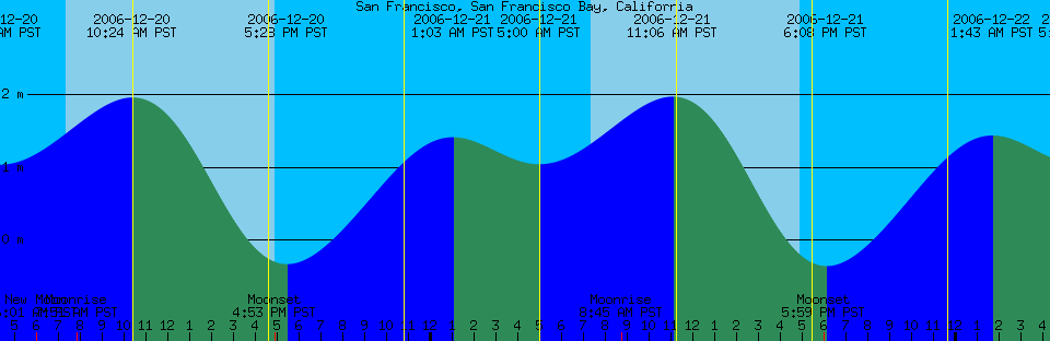
Q: Somebody gave me a tide clock, but the instructions say it only works on the east coast. How can this be?
A: "Dumb" tide clocks assume that the 12 hour 25 minute cycle mentioned in the previous question is a good enough approximation. For the west coast, it isn't. The following tide graphs illustrate the differences between east and west coast tides. The high and low tide times that would be indicated by a "dumb" tide clock are shown with vertical yellow lines. San Francisco shows a 2-hour discrepancy on the lower high tide.
A: The tides do not coincide too closely with the moon. While the moon produces most of the force that drives them, the exact tide levels result from the sloshing around of huge amounts of water, the effects of the shape of the coastline, and things like that.
Q: If it's high tide here, is it low tide in [faraway place]?
A: It's hard to infer anything over large distances since localized effects can have a huge influence on tides.
Q: What does the zero (0) on a tide chart represent?
A: Tide heights are given relative to the "datum" which in most cases is one of several benchmarks corresponding to low tides of varying extremeness. The preferred benchmark in the U.S. is Mean Lower Low Water (MLLW). The odds of the predicted tide getting below MLLW on any given day are about half. The preferred benchmark in the Netherlands is Mean Low Water Springs (MLWS). MLWS is lower than MLLW. The predicted tide will get below MLWS on average only about twice a month. The preferred benchmark in Germany is Lowest Astronomical Tide (LAT). LAT is the lowest tide predicted over a 19 year period. The predicted tide will not get below LAT in that 19 year period, and is unlikely to get below it by any significant amount ever.
In harmonics-dwf, some U.S. locations for which a MLLW benchmark was unavailable use an estimated value of MLLW that is derived from the predictions. These estimates tend to yield predictions that differ from National Ocean Service published tables by (0.1 to 0.2) ft. Older versions of harmonics-dwf used LAT for these stations, which of course yielded much larger discrepancies.
For more information on datums, read the National Ocean Service publication Tidal Datums and their Applications.
A: When the water tries to follow the moon, it runs up against a lot of obstacles, including its own inertia, the shape of the coastline, and the resonances that are set up by the continual tidal motion. In some cases the tides are fighting a permanent current, e.g., going up a river, and this slows down the tidal crest. The result is that the tides at any one place at any given time don't have a whole lot to do with the moon any more.
Q: Why are there two high tides per day, anyway? How is this possible?
A: The standard simple answer to this question is that the water on the side of the earth opposite the moon bulges out due to decreased lunar gravity in the same way that the water on the side of the earth nearest the moon bulges out due to increased lunar gravity. This is counter-intuitive in that one might expect all of the water to just rush over to the side where the moon is. To explain this, I quote from "Our Restless Tides," a NOAA tutorial at https://tidesandcurrents.noaa.gov/restles1.html:
To all outward appearances, the moon revolves around the earth, but in actuality, the moon and earth revolve together around their common center of mass, or gravity. The two astronomical bodies are held together by gravitational attraction, but are simultaneously kept apart by an equal and opposite centrifugal force produced by their individual revolutions around the center-of-mass of the earth-moon system. This balance of forces in orbital revolution applies to the center-of-mass of the individual bodies only. At the earth's surface, an imbalance between these two forces results in the fact that there exists, on the hemisphere of the earth turned toward the moon, a net (or differential) tide-producing force which acts in the direction of the moon's gravitational attraction, or toward the center of the moon. On the side of the earth directly opposite the moon, the net tide-producing force is in the direction of the greater centrifugal force, or away from the moon.
Q: What does "slack water" mean?
A: This and many other terms are defined in the NOAA tide glossary.
A: There is no support for this in XTide (ocean tides have only the vaguest connection to latitude, longitude, and the position of the moon), but you can find relevant information by searching the web for "land tide."
A: The tide prediction function is fairly simple, requiring only a cosine function. The piles of code surrounding it in XTide are to optimize the process of finding maxima and minima. This can be done less optimally with significantly less code and effort (as early versions of XTide did).
Here is the BASIC pseudocode to generate the tide height or current velocity for a specified time point:
Height = Datum
for a = 1 to numconst
Height = Height + amplitude[a] * nodefactor[a] * cos (speed[a] * time + eqarg[a] − phase[a])
next a
The different quantities referenced are:
The speeds, equilibrium arguments, and node factors for arbitrary constituents and time periods can be generated using Congen.
Q: I want to license XTide so I can build a commercial product around it.
A: XTide is released under the terms of the GNU General Public License. This FAQ about the GPL may be applicable to you.
XTide has been used by commercial packages "at arm's length," to use the wording of the FAQ cited above, but I have never licensed it by any terms other than the GPL, nor have I ever offered any kind of warranty or service that one might expect if it were licensed commercially.
PLEASE NOTE: The question whether you can use XTide is completely separate from the question of whether you can use the tide data (harmonics files). In general, data for U.S. ports are public domain, while others are for non-commercial use only or subject to restrictive copyright. Read the boilerplate for details.
Q: I have a lot of specific questions about the GNU General Public License and/or want a ruling that my specific plan is OK.
A: Please read the GPL FAQ, available here. If that does not answer your question, the people to ask are at licensing@fsf.org.
Q: I would like to talk to you concerning the use of your stuff in our upcoming product. Please call me at your convenience. [#include email legal disclaimer]
A: Your questions have already been answered here and maybe here. There is nothing else to talk about.
Q: I really don't understand the whole purpose of the GNU license. Why should I have to reinvent the wheel just because I won't publish my sources?
A: XTide is free software. The GPL gives you the choice between respecting that freedom and passing it on, or reinventing the wheel. Some additional background on the rationale behind the GPL is available from the Free Software Foundation.
Q: We are a not-for-profit organization and we want to sell calendars with predictions from your web site. Is that OK?
A: Firstly, it's not my web site. See Question 1. Secondly, all predictions for places outside the U.S. are for non-commercial use only (i.e. you can't sell them no matter what your tax status is). Lastly, if you do want to sell calendars containing predictions for the U.S., you must include all of the "NOT FOR NAVIGATION" disclaimers and agree to accept full liability in case someone has a problem.
Legalities aside, my opinion has always been that people who are selling tide predictions have no business selling anything that is not directly certified by the National Ocean Service. Beggars can't be choosers, but when people are paying for something, they have a right to hold you to a higher standard.
Q: I have a great idea to make money selling tide predictions, but I'm not good with technical stuff, so would you just do this for me...
A: No.
Q: I already make money selling tide prediction products, but your stuff is better, so would you just do this for me...
A: No.
Q: I just put up a fabulous website that serves up XTide output surrounded by banner ads that make me tons of free money. Would you please link to it?
A: No.
Q: Hey, that previous guy had a great idea. Would you please install XTide on my web server for me?
A: No.
Q: I'm a consultant being paid to install XTide. I'm having a million problems with it, but I can't describe them accurately because I have never used Linux before. I think XTide must be really broken. Please fix all of my problems.
A: Sorry, I can't do that by email.
Q: I need to do [poorly researched brainstorm having something to do with tide prediction]—how much would you charge in consulting fees to help me do it?
A: It's moot. Your plan won't work for one or more of the following reasons:
Q: Congratulations! XTide has been added to some online directory of software packages. Please verify that the information on XTide is correct and keep it updated.
A: Congratulations! No. You do it.
Q: How should I cite XTide within publications?
A: The web site is the best thing you can cite. For a general reference to XTide, I suggest the following, with the current date.
[1] David Flater. XTide. https://flaterco.com/xtide/. 2005-07-04.If you are using specific predictions from XTide rather than just XTide in general, then you should cite the specific version of XTide and the specific data file that you used. In this case, it would be appropriate to use the date indicated in the changelog for that version of XTide and the revision date of the data file.
[2] David Flater. XTide version 2.8.2. https://flaterco.com/xtide/. 2005-01-06.
[3] harmonics-dwf-2005-06-05-v2. Available from https://flaterco.com/xtide/files.html, 2005-06-05.
Q: What is the difference between a reference station and a subordinate station?
A: The following information was copied from NOAA's web site on 2007-02-17.
The publication of full daily tide predictions is necessarily limited to a comparatively small number of stations. These stations are referred to as "reference stations". Tide predictions for more than 3000 other locations, referred to as "subordinate stations", can be obtained by applying specific differences to the daily tide predictions for one of the reference stations. [...]
Caution: The time differences and height ratios used to calculate predictions at subordinate stations are derived from a comparison of simultaneous tide observations at the subordinate station and its reference station. Because these adjustments are constant, they may not always provide for the daily variations in the actual tides, especially if the subordinate station is some distance from the reference station. Therefore, although the application of time differences and height ratios will generally provide reasonably accurate approximations, they cannot result in predictions as accurate as those listed for the reference stations, which are based on much larger periods of analysis.
In plain language, what you need to know is this: All subordinate station predictions are approximate. Tide predictions are always at best approximations of reality, but for subordinate stations that goes double.
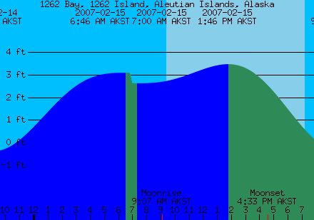
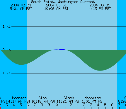
Q: These predictions are nonsense—what is going on here?
|
2007-02-14 12:57 PM AKST 3.46 feet High Tide 2007-02-14 3:00 PM AKST Moonset 2007-02-14 7:08 PM AKST Sunset 2007-02-14 9:06 PM AKST -0.38 feet Low Tide 2007-02-15 6:46 AM AKST 3.08 feet Low Tide 2007-02-15 7:00 AM AKST 2.62 feet High Tide 2007-02-15 9:07 AM AKST Moonrise 2007-02-15 9:22 AM AKST Sunrise 2007-02-15 1:46 PM AKST 3.46 feet High Tide |
|
2004-03-31 5:01 AM PST -0.64 knots Max Ebb 2004-03-31 5:49 AM PST Sunrise 2004-03-31 10:06 AM PST 0.02 knots Max Flood 2004-03-31 10:18 AM PST 0.00 knots Slack, Flood Begins 2004-03-31 11:21 AM PST -0.00 knots Slack, Ebb Begins 2004-03-31 1:01 PM PST Moonrise 2004-03-31 4:13 PM PST -0.90 knots Max Ebb |
These are extreme examples of what can happen when the time differences and height ratios for subordinate stations don't "provide for the daily variations in the actual tides." Although in the average case the offsets might yield good results, in extreme cases they can yield nonsense results like tide events happening in an impossible order or a "low" tide actually being higher than the "high" tide right next to it. There is nothing XTide can do to rationalize these paradoxes, and the tide levels that are interpolated between paradoxical events are essentially garbage.
Q: Where can I find tons of information about tides that is both more authoritative and better written than this FAQ?
A: https://tidesandcurrents.noaa.gov/education.html